


Solwaster

Ban
Gebruiker
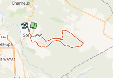

Lengte
11,6 km

Max. hoogte
610 m

Positief hoogteverschil
265 m
Km-Effort
15,1 km

Min. hoogte
363 m

Negatief hoogteverschil
265 m
Boucle
Ja
Datum van aanmaak :
2020-08-09 07:08:48.0
Laatste wijziging :
2020-08-09 09:34:12.866
2h18
Moeilijkheid : Onbekend

Gratisgps-wandelapplicatie
 SityTrail
IGN / Geografische instituten
SityTrail Plus
De wereld gaat voor u open
Over ons
Tocht Stappen van 11,6 km beschikbaar op Wallonië, Luik, Jalhay. Deze tocht wordt voorgesteld door Ban.
Beschrijving
Balade congés 2020 le 9/8/292
Plaatsbepaling
Land:
Belgium
Regio :
Wallonië
Departement/Provincie :
Luik
Gemeente :
Jalhay
Locatie:
Sart
Vertrek:(Dec)
Vertrek:(UTM)
710087 ; 5601276 (31U) N.
Opmerkingen