


CTM 06 sept 2020

PhilippeC54
Gebruiker

Lengte
35 km

Max. hoogte
383 m

Positief hoogteverschil
621 m
Km-Effort
43 km

Min. hoogte
177 m

Negatief hoogteverschil
617 m
Boucle
Neen
Datum van aanmaak :
2020-09-06 06:30:33.977
Laatste wijziging :
2020-09-08 06:25:21.298
2h43
Moeilijkheid : Medium

Gratisgps-wandelapplicatie
 SityTrail
IGN / Geografische instituten
SityTrail Plus
De wereld gaat voor u open
Over ons
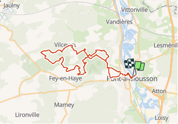
Tocht Mountainbike van 35 km beschikbaar op Grand Est, Meurthe-et-Moselle, Pont-à-Mousson. Deze tocht wordt voorgesteld door PhilippeC54.
Beschrijving
Nouvelles monotraces dans Bois le Prêtre
Plaatsbepaling
Land:
France
Regio :
Grand Est
Departement/Provincie :
Meurthe-et-Moselle
Gemeente :
Pont-à-Mousson
Locatie:
Unknown
Vertrek:(Dec)
Vertrek:(UTM)
284244 ; 5420956 (32U) N.
Opmerkingen