


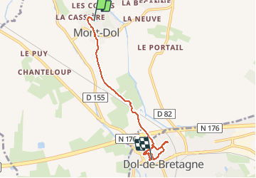
Du mont dol a Dol

eric.deniau
Gebruiker

Lengte
5,1 km

Max. hoogte
60 m

Positief hoogteverschil
45 m
Km-Effort
5,8 km

Min. hoogte
-1 m

Negatief hoogteverschil
86 m
Boucle
Neen
Datum van aanmaak :
2020-09-06 07:40:48.0
Laatste wijziging :
2020-09-06 10:14:53.882
2h34
Moeilijkheid : Onbekend

Gratisgps-wandelapplicatie
 SityTrail
IGN / Geografische instituten
SityTrail Plus
De wereld gaat voor u open
Over ons
Tocht Stappen van 5,1 km beschikbaar op Bretagne, Ille-et-Vilaine, Mont-Dol. Deze tocht wordt voorgesteld door eric.deniau.
Plaatsbepaling
Land:
France
Regio :
Bretagne
Departement/Provincie :
Ille-et-Vilaine
Gemeente :
Mont-Dol
Locatie:
Unknown
Vertrek:(Dec)
Vertrek:(UTM)
590823 ; 5380615 (30U) N.
Opmerkingen