


2020 09 COURANCE T1

michel1025
Gebruiker

Lengte
17 km

Max. hoogte
136 m

Positief hoogteverschil
216 m
Km-Effort
19,8 km

Min. hoogte
59 m

Negatief hoogteverschil
218 m
Boucle
Ja
Datum van aanmaak :
2020-09-10 07:51:28.0
Laatste wijziging :
2020-09-10 16:00:39.366
4h53
Moeilijkheid : Onbekend

Gratisgps-wandelapplicatie
 SityTrail
IGN / Geografische instituten
SityTrail Plus
De wereld gaat voor u open
Over ons
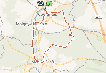
Tocht Stappen van 17 km beschikbaar op Île-de-France, Essonne, Courances. Deze tocht wordt voorgesteld door michel1025.
Plaatsbepaling
Land:
France
Regio :
Île-de-France
Departement/Provincie :
Essonne
Gemeente :
Courances
Locatie:
Unknown
Vertrek:(Dec)
Vertrek:(UTM)
461010 ; 5365730 (31U) N.
Opmerkingen