


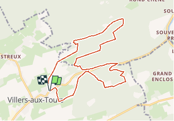
Villers aux Tours

AnneCecile
Gebruiker

Lengte
10,2 km

Max. hoogte
290 m

Positief hoogteverschil
287 m
Km-Effort
14 km

Min. hoogte
186 m

Negatief hoogteverschil
290 m
Boucle
Ja
Datum van aanmaak :
2020-09-19 17:38:06.323
Laatste wijziging :
2020-09-19 17:45:37.971
3h49
Moeilijkheid : Moeilijk

Gratisgps-wandelapplicatie
 SityTrail
IGN / Geografische instituten
SityTrail Plus
De wereld gaat voor u open
Over ons
Tocht Stappen van 10,2 km beschikbaar op Wallonië, Luik, Anthisnes. Deze tocht wordt voorgesteld door AnneCecile.
Beschrijving
Départ croisement Rue Fecher et rue du village
Plaatsbepaling
Land:
Belgium
Regio :
Wallonië
Departement/Provincie :
Luik
Gemeente :
Anthisnes
Locatie:
Villers-aux-Tours
Vertrek:(Dec)
Vertrek:(UTM)
678538 ; 5597128 (31U) N.
Opmerkingen