Tocht Wegfiets Aywaille - Spa - Photo
 kodak
kodak

Gebruiker

© OpenStreetMap contributors
Lengte
Lengte
25 km
Max. hoogte
Max. hoogte
430 m
Positief hoogteverschil
551 m
Km-Effort
Km-Effort  
32 km
Min. hoogte
Min. hoogte
119 m
Negatief hoogteverschil
426 m
Boucle
Boucle
Neen
Datum van aanmaak :
2020-09-20 07:46:40.605
Laatste wijziging :
2020-09-20 07:49:55.351

(0 Bericht)

Wegfiets
Wegfiets
1h51
Moeilijkheid : Medium

Scan deze QR-code om de tocht te openen in de SityTrail-applicatie

Gratisgps-wandelapplicatie

Logo SityTrail SityTrail

IGN / Geografische instituten

SityTrail uit de App Store downloaden SityTrail uit Google Play downloaden

Logo SityTrail SityTrail Plus

De wereld gaat voor u open

SityTrail uit de App Store downloaden SityTrail uit Google Play downloaden SityTrail op Huawei AppGallery downloaden

Over ons

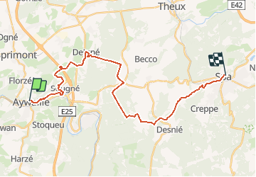
Tocht Wegfiets van 25 km beschikbaar op Wallonië, Luik, Aywaille. Deze tocht wordt voorgesteld door kodak.

Hoogteprofiel

POI's

POI Aywaille - 45 +46 - Photo
kodak
AYWAILLE 
POI Aywaille - 46 +5 - Photo
kodak
AYWAILLE 
POI Aywaille - 5 +6 - Photo
kodak
AYWAILLE 
POI Aywaille - 6 +7 - Photo
kodak
AYWAILLE 
POI Aywaille - 7 +8 - Photo
kodak
AYWAILLE 
POI Theux - 8 +11 - Photo
kodak
THEUX 
POI Theux - 11 +12 - Photo
kodak
THEUX 
POI Theux - 12 +13 - Photo
kodak
THEUX 
POI Theux - 13 +14 - Photo
kodak
THEUX 
POI Theux - 14 +58 - Photo
kodak
THEUX 
POI Theux - 58 - Photo
kodak
THEUX 

Plaatsbepaling

Land:
Belgium
Regio :
Wallonië
Departement/Provincie :
Luik
Gemeente :
Aywaille
Locatie:
Aywaille
Vertrek:(UTM)
689801 ; 5595022 (31U) N.


Sluiten
Mijn abonnementen