


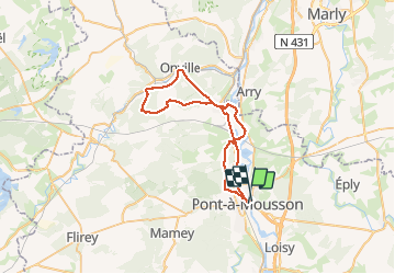
Vallée du rupt de Mad

PhilippeC54
Gebruiker

Lengte
45 km

Max. hoogte
369 m

Positief hoogteverschil
740 m
Km-Effort
55 km

Min. hoogte
168 m

Negatief hoogteverschil
737 m
Boucle
Neen
Datum van aanmaak :
2020-09-20 06:32:09.796
Laatste wijziging :
2020-09-20 09:52:56.335
2h49
Moeilijkheid : Gemakkelijk

Gratisgps-wandelapplicatie
 SityTrail
IGN / Geografische instituten
SityTrail Plus
De wereld gaat voor u open
Over ons
Tocht Mountainbike van 45 km beschikbaar op Grand Est, Meurthe-et-Moselle, Pont-à-Mousson. Deze tocht wordt voorgesteld door PhilippeC54.
Plaatsbepaling
Land:
France
Regio :
Grand Est
Departement/Provincie :
Meurthe-et-Moselle
Gemeente :
Pont-à-Mousson
Locatie:
Unknown
Vertrek:(Dec)
Vertrek:(UTM)
284271 ; 5420974 (32U) N.
Opmerkingen