


Senlis

petergole
Gebruiker
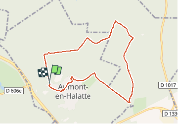

Lengte
8,6 km

Max. hoogte
148 m

Positief hoogteverschil
113 m
Km-Effort
10,1 km

Min. hoogte
88 m

Negatief hoogteverschil
123 m
Boucle
Ja
Datum van aanmaak :
2020-09-19 15:38:40.0
Laatste wijziging :
2020-09-21 13:30:46.994
2h06
Moeilijkheid : Onbekend

Gratisgps-wandelapplicatie
 SityTrail
IGN / Geografische instituten
SityTrail Plus
De wereld gaat voor u open
Over ons
Tocht Stappen van 8,6 km beschikbaar op Hauts-de-France, Oise, Aumont-en-Halatte. Deze tocht wordt voorgesteld door petergole.
Plaatsbepaling
Land:
France
Regio :
Hauts-de-France
Departement/Provincie :
Oise
Gemeente :
Aumont-en-Halatte
Locatie:
Unknown
Vertrek:(Dec)
Vertrek:(UTM)
466950 ; 5453299 (31U) N.
Opmerkingen