


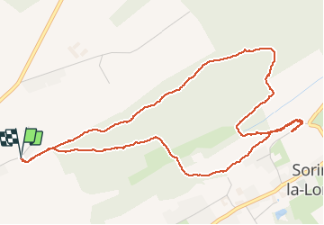
SorinneLL retour par versant sous Les Ruelles

thomarche
Gebruiker

Lengte
5,8 km

Max. hoogte
280 m

Positief hoogteverschil
112 m
Km-Effort
7,3 km

Min. hoogte
218 m

Negatief hoogteverschil
112 m
Boucle
Ja
Datum van aanmaak :
2020-10-18 14:17:36.0
Laatste wijziging :
2024-12-12 11:21:26.6
1h45
Moeilijkheid : Onbekend

Gratisgps-wandelapplicatie
 SityTrail
IGN / Geografische instituten
SityTrail Plus
De wereld gaat voor u open
Over ons
Tocht Stappen van 5,8 km beschikbaar op Wallonië, Namen, Assesse. Deze tocht wordt voorgesteld door thomarche.
Beschrijving
Toujours aussi sublime. Quasi que du bois (très beaux arbres, ambiances) et de très très beaux chemins, et même vues.
Plaatsbepaling
Land:
Belgium
Regio :
Wallonië
Departement/Provincie :
Namen
Gemeente :
Assesse
Locatie:
Unknown
Vertrek:(Dec)
Vertrek:(UTM)
642210 ; 5584025 (31U) N.
Opmerkingen