


our 30 octobre

libinsport
Gebruiker
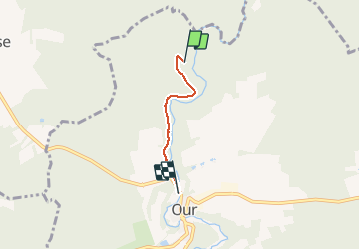

Lengte
2,3 km

Max. hoogte
321 m

Positief hoogteverschil
35 m
Km-Effort
2,8 km

Min. hoogte
304 m

Negatief hoogteverschil
37 m
Boucle
Neen
Datum van aanmaak :
2020-10-31 15:22:07.763
Laatste wijziging :
2020-11-01 08:19:10.56
28m
Moeilijkheid : Heel gemakkelijk

Gratisgps-wandelapplicatie
 SityTrail
IGN / Geografische instituten
SityTrail Plus
De wereld gaat voor u open
Over ons
Tocht Stappen van 2,3 km beschikbaar op Wallonië, Luxemburg, Paliseul. Deze tocht wordt voorgesteld door libinsport.
Plaatsbepaling
Land:
Belgium
Regio :
Wallonië
Departement/Provincie :
Luxemburg
Gemeente :
Paliseul
Locatie:
Opont
Vertrek:(Dec)
Vertrek:(UTM)
652287 ; 5538165 (31U) N.
Opmerkingen