


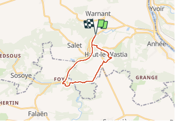
Molignee (Ht Le Wastia) Ruines Montaigle Ravel

thomarche
Gebruiker

Lengte
9,2 km

Max. hoogte
220 m

Positief hoogteverschil
213 m
Km-Effort
12,1 km

Min. hoogte
109 m

Negatief hoogteverschil
213 m
Boucle
Ja
Datum van aanmaak :
2020-11-08 11:58:56.0
Laatste wijziging :
2020-11-08 14:44:22.716
2h44
Moeilijkheid : Onbekend

Gratisgps-wandelapplicatie
 SityTrail
IGN / Geografische instituten
SityTrail Plus
De wereld gaat voor u open
Over ons
Tocht Stappen van 9,2 km beschikbaar op Wallonië, Namen, Anhée. Deze tocht wordt voorgesteld door thomarche.
Plaatsbepaling
Land:
Belgium
Regio :
Wallonië
Departement/Provincie :
Namen
Gemeente :
Anhée
Locatie:
Warnant
Vertrek:(Dec)
Vertrek:(UTM)
630621 ; 5575160 (31U) N.
Opmerkingen