


Noiseux ac

colsonandre
Gebruiker
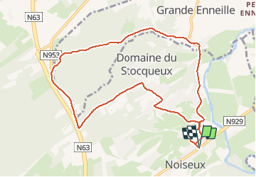

Lengte
9,7 km

Max. hoogte
271 m

Positief hoogteverschil
167 m
Km-Effort
11,9 km

Min. hoogte
162 m

Negatief hoogteverschil
168 m
Boucle
Ja
Datum van aanmaak :
2020-11-18 07:47:14.822
Laatste wijziging :
2020-11-18 10:25:50.354
2h37
Moeilijkheid : Gemakkelijk

Gratisgps-wandelapplicatie
 SityTrail
IGN / Geografische instituten
SityTrail Plus
De wereld gaat voor u open
Over ons
Tocht Stappen van 9,7 km beschikbaar op Wallonië, Namen, Somme-Leuze. Deze tocht wordt voorgesteld door colsonandre.
Beschrijving
belle
Plaatsbepaling
Land:
Belgium
Regio :
Wallonië
Departement/Provincie :
Namen
Gemeente :
Somme-Leuze
Locatie:
Noiseux
Vertrek:(Dec)
Vertrek:(UTM)
669289 ; 5574708 (31U) N.
Opmerkingen