


Goyet Haltinne

thomarche
Gebruiker
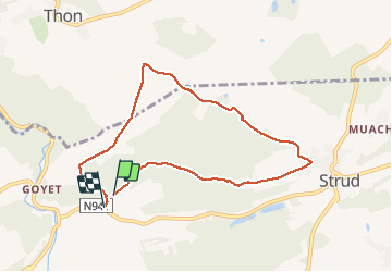

Lengte
7,2 km

Max. hoogte
219 m

Positief hoogteverschil
165 m
Km-Effort
9,4 km

Min. hoogte
122 m

Negatief hoogteverschil
177 m
Boucle
Ja
Datum van aanmaak :
2020-11-22 11:29:04.0
Laatste wijziging :
2020-11-22 13:39:34.772
2h04
Moeilijkheid : Onbekend

Gratisgps-wandelapplicatie
 SityTrail
IGN / Geografische instituten
SityTrail Plus
De wereld gaat voor u open
Over ons
Tocht Stappen van 7,2 km beschikbaar op Wallonië, Namen, Gesves. Deze tocht wordt voorgesteld door thomarche.
Beschrijving
Belle marche balisée entièrement dans terrains entièrement privés et interdits
Plaatsbepaling
Land:
Belgium
Regio :
Wallonië
Departement/Provincie :
Namen
Gemeente :
Gesves
Locatie:
Mozet
Vertrek:(Dec)
Vertrek:(UTM)
643528 ; 5590172 (31U) N.
Opmerkingen