


marloie ac

colsonandre
Gebruiker

Lengte
9,2 km

Max. hoogte
304 m

Positief hoogteverschil
163 m
Km-Effort
11,4 km

Min. hoogte
215 m

Negatief hoogteverschil
162 m
Boucle
Ja
Datum van aanmaak :
2020-11-25 07:55:19.833
Laatste wijziging :
2020-11-25 18:32:23.502
2h48
Moeilijkheid : Medium

Gratisgps-wandelapplicatie
 SityTrail
IGN / Geografische instituten
SityTrail Plus
De wereld gaat voor u open
Over ons
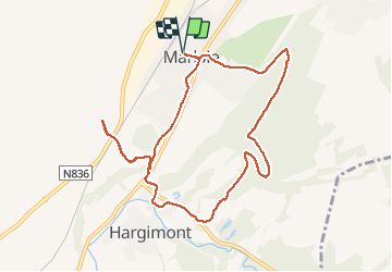
Tocht Stappen van 9,2 km beschikbaar op Wallonië, Luxemburg, Marche-en-Famenne. Deze tocht wordt voorgesteld door colsonandre.
Beschrijving
passages dans le bois soi-disant interdit et chemin inexistant(bwès des leûps) à la fin (d'où le demi tour)
Plaatsbepaling
Land:
Belgium
Regio :
Wallonië
Departement/Provincie :
Luxemburg
Gemeente :
Marche-en-Famenne
Locatie:
Waha
Vertrek:(Dec)
Vertrek:(UTM)
665196 ; 5563515 (31U) N.
Opmerkingen