


Mont Ours depuis col de Castillon

aris
Gebruiker
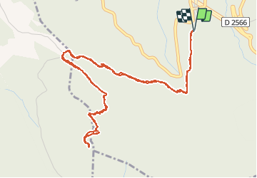

Lengte
7,3 km

Max. hoogte
1229 m

Positief hoogteverschil
499 m
Km-Effort
14 km

Min. hoogte
737 m

Negatief hoogteverschil
498 m
Boucle
Ja
Datum van aanmaak :
2020-12-06 10:04:28.415
Laatste wijziging :
2021-02-13 22:35:16.629
2h25
Moeilijkheid : Gemakkelijk

Gratisgps-wandelapplicatie
 SityTrail
IGN / Geografische instituten
SityTrail Plus
De wereld gaat voor u open
Over ons
Tocht Stappen van 7,3 km beschikbaar op Provence-Alpes-Côte d'Azur, Alpes-Maritimes, Castillon. Deze tocht wordt voorgesteld door aris.
Beschrijving
Randonnée facile de moins de 3h pour confinement version "3h, 20km". Vue panoramique en haut.
Plaatsbepaling
Land:
France
Regio :
Provence-Alpes-Côte d'Azur
Departement/Provincie :
Alpes-Maritimes
Gemeente :
Castillon
Locatie:
Unknown
Vertrek:(Dec)
Vertrek:(UTM)
376231 ; 4854984 (32T) N.
Opmerkingen