


RONVRAI20 14:04:29

UDGI54
Gebruiker
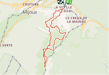

Lengte
9 km

Max. hoogte
1600 m

Positief hoogteverschil
395 m
Km-Effort
14,3 km

Min. hoogte
1317 m

Negatief hoogteverschil
395 m
Boucle
Ja
Datum van aanmaak :
2020-12-13 18:08:58.443
Laatste wijziging :
2020-12-13 18:09:44.018

Gratisgps-wandelapplicatie
 SityTrail
IGN / Geografische instituten
SityTrail Plus
De wereld gaat voor u open
Over ons
Tocht van 9 km beschikbaar op Auvergne-Rhône-Alpes, Ain, Gex. Deze tocht wordt voorgesteld door UDGI54.
Plaatsbepaling
Land:
France
Regio :
Auvergne-Rhône-Alpes
Departement/Provincie :
Ain
Gemeente :
Gex
Locatie:
Unknown
Vertrek:(Dec)
Vertrek:(UTM)
270478 ; 5139243 (32T) N.
Opmerkingen