


TURET 03 11:51:01

UDGI54
Gebruiker
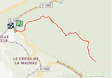

Lengte
5,5 km

Max. hoogte
1416 m

Positief hoogteverschil
172 m
Km-Effort
7,8 km

Min. hoogte
1322 m

Negatief hoogteverschil
179 m
Boucle
Ja
Datum van aanmaak :
2020-12-19 12:37:09.654
Laatste wijziging :
2020-12-19 12:37:54.563

Gratisgps-wandelapplicatie
 SityTrail
IGN / Geografische instituten
SityTrail Plus
De wereld gaat voor u open
Over ons
Tocht van 5,5 km beschikbaar op Auvergne-Rhône-Alpes, Ain, Gex. Deze tocht wordt voorgesteld door UDGI54.
Plaatsbepaling
Land:
France
Regio :
Auvergne-Rhône-Alpes
Departement/Provincie :
Ain
Gemeente :
Gex
Locatie:
Unknown
Vertrek:(Dec)
Vertrek:(UTM)
270777 ; 5139362 (32T) N.
Opmerkingen