


Gouvy . Limerlé . Cherapont . Gouvy

stef789
Gebruiker GUIDE
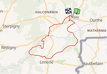

Lengte
15,6 km

Max. hoogte
496 m

Positief hoogteverschil
308 m
Km-Effort
19,7 km

Min. hoogte
410 m

Negatief hoogteverschil
307 m
Boucle
Ja
Datum van aanmaak :
2020-12-30 10:29:59.828
Laatste wijziging :
2020-12-30 17:21:31.408
4h40
Moeilijkheid : Heel gemakkelijk

Gratisgps-wandelapplicatie
 SityTrail
IGN / Geografische instituten
SityTrail Plus
De wereld gaat voor u open
Over ons
Tocht Stappen van 15,6 km beschikbaar op Wallonië, Luxemburg, Gouvy. Deze tocht wordt voorgesteld door stef789.
Foto's


Plaatsbepaling
Land:
Belgium
Regio :
Wallonië
Departement/Provincie :
Luxemburg
Gemeente :
Gouvy
Locatie:
Limerlé
Vertrek:(Dec)
Vertrek:(UTM)
710877 ; 5563905 (31U) N.
Opmerkingen