


Anhée Bsup

pierlan
Gebruiker

Lengte
25 km

Max. hoogte
243 m

Positief hoogteverschil
591 m
Km-Effort
33 km

Min. hoogte
84 m

Negatief hoogteverschil
590 m
Boucle
Ja
Datum van aanmaak :
2021-01-03 10:20:53.446
Laatste wijziging :
2021-01-05 08:35:05.897
--
Moeilijkheid : Heel gemakkelijk

Gratisgps-wandelapplicatie
 SityTrail
IGN / Geografische instituten
SityTrail Plus
De wereld gaat voor u open
Over ons
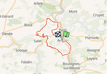
Tocht Trail van 25 km beschikbaar op Wallonië, Namen, Anhée. Deze tocht wordt voorgesteld door pierlan.
Plaatsbepaling
Land:
Belgium
Regio :
Wallonië
Departement/Provincie :
Namen
Gemeente :
Anhée
Locatie:
Anhée
Vertrek:(Dec)
Vertrek:(UTM)
633619 ; 5574715 (31U) N.
Opmerkingen