


fontvannes -4° 10.01.2021

Tollard
Gebruiker
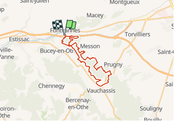

Lengte
27 km

Max. hoogte
267 m

Positief hoogteverschil
544 m
Km-Effort
35 km

Min. hoogte
149 m

Negatief hoogteverschil
545 m
Boucle
Ja
Datum van aanmaak :
2021-01-10 07:57:46.084
Laatste wijziging :
2021-01-10 10:52:21.831
2h54
Moeilijkheid : Medium

Gratisgps-wandelapplicatie
 SityTrail
IGN / Geografische instituten
SityTrail Plus
De wereld gaat voor u open
Over ons
Tocht Mountainbike van 27 km beschikbaar op Grand Est, Aube, Fontvannes. Deze tocht wordt voorgesteld door Tollard.
Plaatsbepaling
Land:
France
Regio :
Grand Est
Departement/Provincie :
Aube
Gemeente :
Fontvannes
Locatie:
Unknown
Vertrek:(Dec)
Vertrek:(UTM)
564732 ; 5347032 (31U) N.
Opmerkingen