


Raid arche nature 5 avril 2014

mouss65
Gebruiker

Lengte
69 km

Max. hoogte
123 m

Positief hoogteverschil
876 m
Km-Effort
81 km

Min. hoogte
37 m

Negatief hoogteverschil
850 m
Boucle
Neen
Datum van aanmaak :
2014-12-10 00:00:00.0
Laatste wijziging :
2014-12-10 00:00:00.0
--
Moeilijkheid : Moeilijk

Gratisgps-wandelapplicatie
 SityTrail
IGN / Geografische instituten
SityTrail Plus
De wereld gaat voor u open
Over ons
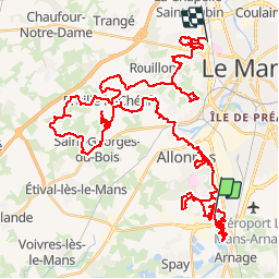
Tocht Mountainbike van 69 km beschikbaar op Pays de la Loire, Sarthe, Arnage. Deze tocht wordt voorgesteld door mouss65.
Beschrijving
Avec Laurent
Plaatsbepaling
Land:
France
Regio :
Pays de la Loire
Departement/Provincie :
Sarthe
Gemeente :
Arnage
Locatie:
Unknown
Vertrek:(Dec)
Vertrek:(UTM)
289146 ; 5314116 (31T) N.
Opmerkingen
