


maredsous

pito0206
Gebruiker
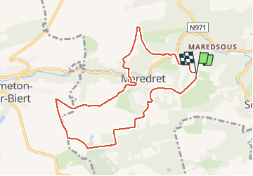

Lengte
8,7 km

Max. hoogte
283 m

Positief hoogteverschil
210 m
Km-Effort
11,5 km

Min. hoogte
174 m

Negatief hoogteverschil
213 m
Boucle
Ja
Datum van aanmaak :
2021-01-10 10:26:17.326
Laatste wijziging :
2021-01-10 12:21:52.881
1h50
Moeilijkheid : Heel gemakkelijk

Gratisgps-wandelapplicatie
 SityTrail
IGN / Geografische instituten
SityTrail Plus
De wereld gaat voor u open
Over ons
Tocht Stappen van 8,7 km beschikbaar op Wallonië, Namen, Anhée. Deze tocht wordt voorgesteld door pito0206.
Plaatsbepaling
Land:
Belgium
Regio :
Wallonië
Departement/Provincie :
Namen
Gemeente :
Anhée
Locatie:
Denée
Vertrek:(Dec)
Vertrek:(UTM)
625731 ; 5573494 (31U) N.
Opmerkingen