


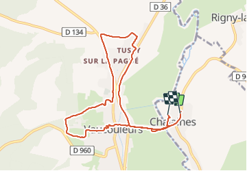
sortie à vaucouleurs

mannequ1
Gebruiker

Lengte
9,1 km

Max. hoogte
349 m

Positief hoogteverschil
140 m
Km-Effort
10,9 km

Min. hoogte
245 m

Negatief hoogteverschil
127 m
Boucle
Neen
Datum van aanmaak :
2014-12-10 00:00:00.0
Laatste wijziging :
2014-12-10 00:00:00.0
2h25
Moeilijkheid : Gemakkelijk

Gratisgps-wandelapplicatie
 SityTrail
IGN / Geografische instituten
SityTrail Plus
De wereld gaat voor u open
Over ons
Tocht Stappen van 9,1 km beschikbaar op Grand Est, Meuse, Chalaines. Deze tocht wordt voorgesteld door mannequ1.
Plaatsbepaling
Land:
France
Regio :
Grand Est
Departement/Provincie :
Meuse
Gemeente :
Chalaines
Locatie:
Unknown
Vertrek:(Dec)
Vertrek:(UTM)
697500 ; 5386927 (31U) N.
Opmerkingen