


Borée Croix Boutières 21km

thonyc
Gebruiker GUIDE
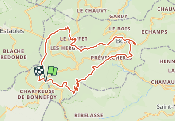

Lengte
21 km

Max. hoogte
1571 m

Positief hoogteverschil
769 m
Km-Effort
31 km

Min. hoogte
997 m

Negatief hoogteverschil
765 m
Boucle
Ja
Datum van aanmaak :
2021-01-23 07:48:34.021
Laatste wijziging :
2024-01-25 10:41:14.41
7h06
Moeilijkheid : Zeer moeilijk

Gratisgps-wandelapplicatie
 SityTrail
IGN / Geografische instituten
SityTrail Plus
De wereld gaat voor u open
Over ons
Tocht Stappen van 21 km beschikbaar op Auvergne-Rhône-Alpes, Ardèche, Borée. Deze tocht wordt voorgesteld door thonyc.
Plaatsbepaling
Land:
France
Regio :
Auvergne-Rhône-Alpes
Departement/Provincie :
Ardèche
Gemeente :
Borée
Locatie:
Unknown
Vertrek:(Dec)
Vertrek:(UTM)
593528 ; 4970054 (31T) N.
Opmerkingen