


itancourt st cantonné 9 02 21

jacquesduchesne
Gebruiker
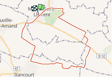

Lengte
9,7 km

Max. hoogte
125 m

Positief hoogteverschil
84 m
Km-Effort
10,8 km

Min. hoogte
99 m

Negatief hoogteverschil
84 m
Boucle
Ja
Datum van aanmaak :
2021-02-08 13:22:13.605
Laatste wijziging :
2021-02-08 15:14:00.893
1h49
Moeilijkheid : Heel gemakkelijk

Gratisgps-wandelapplicatie
 SityTrail
IGN / Geografische instituten
SityTrail Plus
De wereld gaat voor u open
Over ons
Tocht Stappen van 9,7 km beschikbaar op Hauts-de-France, Aisne, Mesnil-Saint-Laurent. Deze tocht wordt voorgesteld door jacquesduchesne.
Plaatsbepaling
Land:
France
Regio :
Hauts-de-France
Departement/Provincie :
Aisne
Gemeente :
Mesnil-Saint-Laurent
Locatie:
Unknown
Vertrek:(Dec)
Vertrek:(UTM)
525375 ; 5519717 (31U) N.
Opmerkingen