


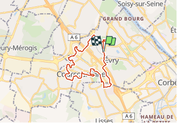
2021 01 EVRY T1

michel1025
Gebruiker

Lengte
13,6 km

Max. hoogte
96 m

Positief hoogteverschil
116 m
Km-Effort
15,1 km

Min. hoogte
70 m

Negatief hoogteverschil
118 m
Boucle
Ja
Datum van aanmaak :
2021-02-09 12:54:24.0
Laatste wijziging :
2021-02-09 15:42:15.798
2h47
Moeilijkheid : Onbekend

Gratisgps-wandelapplicatie
 SityTrail
IGN / Geografische instituten
SityTrail Plus
De wereld gaat voor u open
Over ons
Tocht Stappen van 13,6 km beschikbaar op Île-de-France, Essonne, Évry-Courcouronnes. Deze tocht wordt voorgesteld door michel1025.
Plaatsbepaling
Land:
France
Regio :
Île-de-France
Departement/Provincie :
Essonne
Gemeente :
Évry-Courcouronnes
Locatie:
Courcouronnes
Vertrek:(Dec)
Vertrek:(UTM)
457505 ; 5386244 (31U) N.
Opmerkingen