


chevron

annedogne
Gebruiker
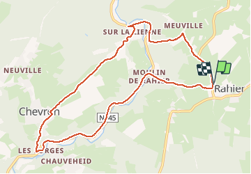

Lengte
9,7 km

Max. hoogte
355 m

Positief hoogteverschil
296 m
Km-Effort
13,7 km

Min. hoogte
219 m

Negatief hoogteverschil
296 m
Boucle
Ja
Datum van aanmaak :
2021-02-17 12:24:18.991
Laatste wijziging :
2021-02-17 14:29:34.362
2h04
Moeilijkheid : Gemakkelijk

Gratisgps-wandelapplicatie
 SityTrail
IGN / Geografische instituten
SityTrail Plus
De wereld gaat voor u open
Over ons
Tocht Noords wandelen van 9,7 km beschikbaar op Wallonië, Luik, Stoumont. Deze tocht wordt voorgesteld door annedogne.
Plaatsbepaling
Land:
Belgium
Regio :
Wallonië
Departement/Provincie :
Luik
Gemeente :
Stoumont
Locatie:
Rahier
Vertrek:(Dec)
Vertrek:(UTM)
697249 ; 5585319 (31U) N.
Opmerkingen