


St nicolas d'Acy

Djaie60
Gebruiker

Lengte
12,6 km

Max. hoogte
70 m

Positief hoogteverschil
111 m
Km-Effort
14,1 km

Min. hoogte
41 m

Negatief hoogteverschil
111 m
Boucle
Ja
Datum van aanmaak :
2021-02-21 12:20:16.0
Laatste wijziging :
2021-04-18 07:39:58.818
3h11
Moeilijkheid : Gemakkelijk

Gratisgps-wandelapplicatie
 SityTrail
IGN / Geografische instituten
SityTrail Plus
De wereld gaat voor u open
Over ons
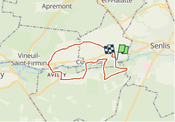
Tocht Te voet van 12,6 km beschikbaar op Hauts-de-France, Oise, Courteuil. Deze tocht wordt voorgesteld door Djaie60.
Plaatsbepaling
Land:
France
Regio :
Hauts-de-France
Departement/Provincie :
Oise
Gemeente :
Courteuil
Locatie:
Unknown
Vertrek:(Dec)
Vertrek:(UTM)
467506 ; 5449740 (31U) N.
Opmerkingen