![](/images/other/stat-length.png)
![Tocht Hybride fiets Cintré - Anniversaire Domi - Photo](https://media.geolcdn.com/t/1900/400/ext.pjpeg?maxdim=2&url=https%3A%2F%2Fmedia.geolcdn.com%2Ff%2F1204a453-6a8d-4331-a1e0-530643ae37ba.jpg)
Anniversaire Domi
randall64
Gebruiker
![Lengte](/images/other/stat-length.png)
Lengte
43 km
![Max. hoogte](https://static1.geolcdn.com/siteimages/upload/files/1508320355ic_sort_altitude_max_24dp.png)
Max. hoogte
57 m
![Positief hoogteverschil](https://static1.geolcdn.com/siteimages/upload/files/1508320355ic_sort_den_pos_24dp.png)
Positief hoogteverschil
330 m
![Km-Effort](/images/other/stat-length.png)
Km-Effort
48 km
![Min. hoogte](https://static1.geolcdn.com/siteimages/upload/files/1508320355ic_sort_altitude_min_24dp.png)
Min. hoogte
18 m
![Negatief hoogteverschil](https://static1.geolcdn.com/siteimages/upload/files/1508320355ic_sort_den_neg_24dp.png)
Negatief hoogteverschil
318 m
![Boucle](https://static1.geolcdn.com/siteimages/upload/files/16400158638029165_repeat_loop_refresh_sync_direction_icon.png)
Boucle
Neen
Datum van aanmaak :
2021-02-25 09:23:12.0
Laatste wijziging :
2021-02-25 15:04:34.116
![Hybride fiets](https://static1.geolcdn.com/sitytour/trail-icons/203.png)
3h03
Moeilijkheid : Gemakkelijk
![Scan deze QR-code om de tocht te openen in de SityTrail-applicatie](https://capi.geolives.com/qq0zvz2zws4bq2lad0pu/sitytour/trails/2684804/qr.png?size=200)
Gratisgps-wandelapplicatie
Over ons
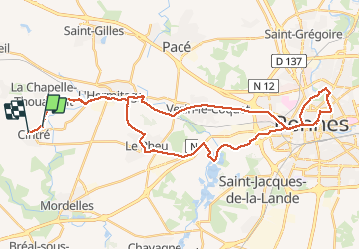
Tocht Hybride fiets van 43 km beschikbaar op Bretagne, Ille-et-Vilaine, Cintré. Deze tocht wordt voorgesteld door randall64.
Beschrijving
Quoi de plus sympa qu’une petite bouffe pour l’anniversaire du copain rennais en liant l’utile à l’agréable ( 45 km aller retour à vélo )
Plaatsbepaling
Land:
France
Regio :
Bretagne
Departement/Provincie :
Ille-et-Vilaine
Gemeente :
Cintré
Locatie:
Unknown
Vertrek:(Dec)
Vertrek:(UTM)
584507 ; 5329126 (30U) N.
Opmerkingen
Wandeltochten in de omgeving
![Tocht Stappen Saint-Gilles - CACE - LA BONNEMAIS 28 KM - Photo](https://media.geolcdn.com/t/375/260/ext.jpg?maxdim=2&url=https%3A%2F%2Fstatic1.geolcdn.com%2Fsiteimages%2Fupload%2Ffiles%2F1553511878bg_sport_marche.png)
![Stappen Stappen](https://static1.geolcdn.com/sitytour/trail-icons/101.png)
CACE - LA BONNEMAIS 28 KM
Stappen
Zeer moeilijk
(1)
Saint-Gilles,
Bretagne,
Ille-et-Vilaine,
France
![](/images/other/stat-length.png)
28 km | 31 km-effort
6h 50min
![](https://static1.geolcdn.com/siteimages/upload/files/16400158638029165_repeat_loop_refresh_sync_direction_icon.png)
Ja
![Tocht Te voet Breteil - La balade de Cohan - Photo](https://media.geolcdn.com/t/375/260/ext.jpg?maxdim=2&url=https%3A%2F%2Fmedia.geolcdn.com%2Ff%2F006bd926-629b-4fd7-b147-3b453121d7be.jpeg)
![Te voet Te voet](https://static1.geolcdn.com/sitytour/trail-icons/100.png)
La balade de Cohan
Te voet
Gemakkelijk
Breteil,
Bretagne,
Ille-et-Vilaine,
France
![](/images/other/stat-length.png)
7,2 km | 7,9 km-effort
1h 47min
![](https://static1.geolcdn.com/siteimages/upload/files/16400158638029165_repeat_loop_refresh_sync_direction_icon.png)
Ja
![Tocht Fiets Le Rheu - Chavagne_Ecluse de Cicé - Photo](https://media.geolcdn.com/t/375/260/ext.jpg?maxdim=2&url=https%3A%2F%2Fmedia.geolcdn.com%2Ff%2Fea4863bf-f81e-40e3-8e2b-d4f532a0ddd0.JPG)
![Fiets Fiets](https://static1.geolcdn.com/sitytour/trail-icons/200.png)
Chavagne_Ecluse de Cicé
Fiets
Gemakkelijk
Le Rheu,
Bretagne,
Ille-et-Vilaine,
France
![](/images/other/stat-length.png)
18,6 km | 20 km-effort
Onbekend
![](https://static1.geolcdn.com/siteimages/upload/files/16400158638029165_repeat_loop_refresh_sync_direction_icon.png)
Ja
![Tocht Stappen La Chapelle-Thouarault - La Chapelle Thouarault - Photo](https://media.geolcdn.com/t/375/260/ext.jpg?maxdim=2&url=https%3A%2F%2Fmedia.geolcdn.com%2Ff%2F9664adfd-f3ab-4d01-9862-f970c7095060.jpg)
![Stappen Stappen](https://static1.geolcdn.com/sitytour/trail-icons/101.png)
La Chapelle Thouarault
Stappen
Heel gemakkelijk
(2)
La Chapelle-Thouarault,
Bretagne,
Ille-et-Vilaine,
France
![](/images/other/stat-length.png)
12,4 km | 13,6 km-effort
3h 1min
![](https://static1.geolcdn.com/siteimages/upload/files/16400158638029165_repeat_loop_refresh_sync_direction_icon.png)
Ja
![Tocht Stappen Saint-Gilles - st Gilles 14.3km facile - Photo](https://media.geolcdn.com/t/375/260/ext.jpg?maxdim=2&url=https%3A%2F%2Fstatic1.geolcdn.com%2Fsiteimages%2Fupload%2Ffiles%2F1553511878bg_sport_marche.png)
![Stappen Stappen](https://static1.geolcdn.com/sitytour/trail-icons/101.png)
st Gilles 14.3km facile
Stappen
Moeilijk
Saint-Gilles,
Bretagne,
Ille-et-Vilaine,
France
![](/images/other/stat-length.png)
14,3 km | 15,8 km-effort
3h 35min
![](https://static1.geolcdn.com/siteimages/upload/files/16400158638029165_repeat_loop_refresh_sync_direction_icon.png)
Ja
![Tocht Stappen Mordelles - Mordelles La voie du Meu - Photo](https://media.geolcdn.com/t/375/260/ext.jpg?maxdim=2&url=https%3A%2F%2Fstatic1.geolcdn.com%2Fsiteimages%2Fupload%2Ffiles%2F1553511878bg_sport_marche.png)
![Stappen Stappen](https://static1.geolcdn.com/sitytour/trail-icons/101.png)
Mordelles La voie du Meu
Stappen
Heel gemakkelijk
Mordelles,
Bretagne,
Ille-et-Vilaine,
France
![](/images/other/stat-length.png)
9 km | 9,9 km-effort
2h 25min
![](https://static1.geolcdn.com/siteimages/upload/files/16400158638029165_repeat_loop_refresh_sync_direction_icon.png)
Ja
![Tocht Stappen Mordelles - Mordilles B1 - Photo](https://media.geolcdn.com/t/375/260/ext.jpg?maxdim=2&url=https%3A%2F%2Fstatic1.geolcdn.com%2Fsiteimages%2Fupload%2Ffiles%2F1553511878bg_sport_marche.png)
![Stappen Stappen](https://static1.geolcdn.com/sitytour/trail-icons/101.png)
Mordilles B1
Stappen
Mordelles,
Bretagne,
Ille-et-Vilaine,
France
![](/images/other/stat-length.png)
9,1 km | 9,9 km-effort
2h 25min
![](https://static1.geolcdn.com/siteimages/upload/files/16400158638029165_repeat_loop_refresh_sync_direction_icon.png)
Ja
![Tocht sport Saint-Gilles - 2024-05-17_08h48m39_Saint Gilles 12k200 - Photo](https://media.geolcdn.com/t/375/260/ext.jpg?maxdim=2&url=https%3A%2F%2Fsecurestorage.geolives.com%2Fsitytour%2Ftrail-bg%2Fdefault.jpg)
2024-05-17_08h48m39_Saint Gilles 12k200
sport
Heel gemakkelijk
Saint-Gilles,
Bretagne,
Ille-et-Vilaine,
France
![](/images/other/stat-length.png)
12,2 km | 13,5 km-effort
Onbekend
![](https://static1.geolcdn.com/siteimages/upload/files/16400158638029165_repeat_loop_refresh_sync_direction_icon.png)
Ja
![Tocht Stappen La Chapelle-Thouarault - A+/La Chapelle-Thouarault/8-02-2024 - Photo](https://media.geolcdn.com/t/375/260/ext.jpg?maxdim=2&url=https%3A%2F%2Fstatic1.geolcdn.com%2Fsiteimages%2Fupload%2Ffiles%2F1553511878bg_sport_marche.png)
![Stappen Stappen](https://static1.geolcdn.com/sitytour/trail-icons/101.png)
A+/La Chapelle-Thouarault/8-02-2024
Stappen
Moeilijk
La Chapelle-Thouarault,
Bretagne,
Ille-et-Vilaine,
France
![](/images/other/stat-length.png)
14,2 km | 15,6 km-effort
3h 32min
![](https://static1.geolcdn.com/siteimages/upload/files/16400158638029165_repeat_loop_refresh_sync_direction_icon.png)
Ja