Tocht Stappen Aywaille - Raborive-Awan-Septroux - Photo

Raborive-Awan-Septroux

 suntajl
suntajl

Gebruiker

© OpenStreetMap contributors
Lengte
Lengte
7,1 km
Max. hoogte
Max. hoogte
292 m
Positief hoogteverschil
225 m
Km-Effort
Km-Effort  
10,1 km
Min. hoogte
Min. hoogte
119 m
Negatief hoogteverschil
226 m
Boucle
Boucle
Ja
Datum van aanmaak :
2021-02-28 10:09:41.261
Laatste wijziging :
2021-02-28 15:20:10.55

(0 Bericht)

Stappen
Stappen
1h52
Moeilijkheid : Gemakkelijk

Scan deze QR-code om de tocht te openen in de SityTrail-applicatie

Gratisgps-wandelapplicatie

Logo SityTrail SityTrail

IGN / Geografische instituten

SityTrail uit de App Store downloaden SityTrail uit Google Play downloaden

Logo SityTrail SityTrail Plus

De wereld gaat voor u open

SityTrail uit de App Store downloaden SityTrail uit Google Play downloaden SityTrail op Huawei AppGallery downloaden

Over ons

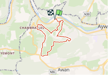
Tocht Stappen van 7,1 km beschikbaar op Wallonië, Luik, Aywaille. Deze tocht wordt voorgesteld door suntajl.

Beschrijving

P facile en-dessous du pont ou juste après. Suit partiellement la promenade P7 d'Aywaille. En général, bons chemins. paysages, bois, prairies. Super vue sur le chateau d'Emblève, passage à la croix de Septroux et aux Tartines de Chambralles (ancienne carrière)

Hoogteprofiel

Plaatsbepaling

Land:
Belgium
Regio :
Wallonië
Departement/Provincie :
Luik
Gemeente :
Aywaille
Locatie:
Aywaille
Vertrek:(Dec)
Vertrek:(UTM)
687748 ; 5595167 (31U) N.


Sluiten
Mijn abonnementen