


GTMC J2

PhilippeC54
Gebruiker
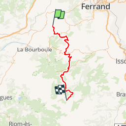

Lengte
59 km

Max. hoogte
1291 m

Positief hoogteverschil
1863 m
Km-Effort
83 km

Min. hoogte
857 m

Negatief hoogteverschil
1526 m
Boucle
Neen
Datum van aanmaak :
2017-06-17 00:00:00.0
Laatste wijziging :
2017-06-17 00:00:00.0
6h00
Moeilijkheid : Medium

Gratisgps-wandelapplicatie
 SityTrail
IGN / Geografische instituten
SityTrail Plus
De wereld gaat voor u open
Over ons
Tocht Mountainbike van 59 km beschikbaar op Auvergne-Rhône-Alpes, Puy-de-Dôme, Orcival. Deze tocht wordt voorgesteld door PhilippeC54.
Beschrijving
5 : Orcival - Pessade
6 : Pessade - St Victor-la-Riviere
7 : St Victor - Lac de Montcineyre
8 : Lac de Montcineyre - La Godivelle
Plaatsbepaling
Land:
France
Regio :
Auvergne-Rhône-Alpes
Departement/Provincie :
Puy-de-Dôme
Gemeente :
Orcival
Locatie:
Unknown
Vertrek:(Dec)
Vertrek:(UTM)
487685 ; 5058867 (31T) N.
Opmerkingen