


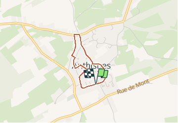
AS07 Boucle de l'architecture villageoise

Trails in Esneux
Discover trails in Esneux GUIDE+

Lengte
2,1 km

Max. hoogte
280 m

Positief hoogteverschil
40 m
Km-Effort
2,7 km

Min. hoogte
239 m

Negatief hoogteverschil
41 m
Boucle
Ja
Datum van aanmaak :
2021-03-08 11:03:08.994
Laatste wijziging :
2021-03-08 11:04:45.556
35m
Moeilijkheid : Gemakkelijk

Gratisgps-wandelapplicatie
 SityTrail
IGN / Geografische instituten
SityTrail Plus
De wereld gaat voor u open
Over ons
Tocht Te voet van 2,1 km beschikbaar op Wallonië, Luik, Anthisnes. Deze tocht wordt voorgesteld door Trails in Esneux.
Beschrijving
Suivez la balisage Rectangle Vert.
Plaatsbepaling
Land:
Belgium
Regio :
Wallonië
Departement/Provincie :
Luik
Gemeente :
Anthisnes
Locatie:
Anthisnes
Vertrek:(Dec)
Vertrek:(UTM)
679025 ; 5594999 (31U) N.
Opmerkingen