


Marche F.F.B.M.P. Aubel 2021 (22 kms)

NicolasWillem89
Gebruiker
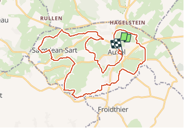

Lengte
22 km

Max. hoogte
260 m

Positief hoogteverschil
386 m
Km-Effort
28 km

Min. hoogte
161 m

Negatief hoogteverschil
372 m
Boucle
Neen
Datum van aanmaak :
2021-03-21 09:20:23.802
Laatste wijziging :
2021-03-21 13:46:06.105
4h07
Moeilijkheid : Gemakkelijk

Gratisgps-wandelapplicatie
 SityTrail
IGN / Geografische instituten
SityTrail Plus
De wereld gaat voor u open
Over ons
Tocht Stappen van 22 km beschikbaar op Wallonië, Luik, Aubel. Deze tocht wordt voorgesteld door NicolasWillem89.
Beschrijving
Parcours des 21 kms, édition COVID-19, mélange de routes et sentiers
Plaatsbepaling
Land:
Belgium
Regio :
Wallonië
Departement/Provincie :
Luik
Gemeente :
Aubel
Locatie:
Aubel
Vertrek:(Dec)
Vertrek:(UTM)
701945 ; 5620972 (31U) N.
Opmerkingen