


Noirefontaine par le sati 3x

Beranger Guillaume
Gebruiker
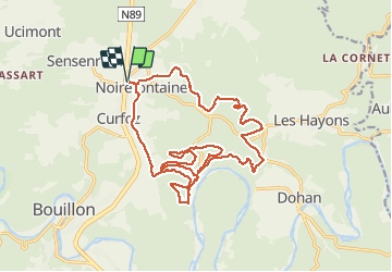

Lengte
19,9 km

Max. hoogte
408 m

Positief hoogteverschil
826 m
Km-Effort
31 km

Min. hoogte
228 m

Negatief hoogteverschil
826 m
Boucle
Ja
Datum van aanmaak :
2021-03-22 08:52:28.941
Laatste wijziging :
2021-03-22 13:45:33.917
4h51
Moeilijkheid : Zeer moeilijk

Gratisgps-wandelapplicatie
 SityTrail
IGN / Geografische instituten
SityTrail Plus
De wereld gaat voor u open
Over ons
Tocht Stappen van 19,9 km beschikbaar op Wallonië, Luxemburg, Bouillon. Deze tocht wordt voorgesteld door Beranger Guillaume.
Plaatsbepaling
Land:
Belgium
Regio :
Wallonië
Departement/Provincie :
Luxemburg
Gemeente :
Bouillon
Locatie:
Noirefontaine
Vertrek:(Dec)
Vertrek:(UTM)
650166 ; 5520815 (31U) N.
Opmerkingen