


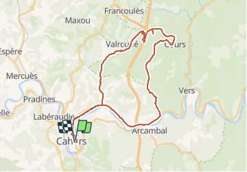
Cahors sortie VTT 40 km dans vallons au nord

fxhedon
Gebruiker

Lengte
38 km

Max. hoogte
355 m

Positief hoogteverschil
502 m
Km-Effort
45 km

Min. hoogte
115 m

Negatief hoogteverschil
504 m
Boucle
Ja
Datum van aanmaak :
2021-03-23 09:29:36.0
Laatste wijziging :
2021-03-23 12:43:36.88
3h12
Moeilijkheid : Onbekend

Gratisgps-wandelapplicatie
 SityTrail
IGN / Geografische instituten
SityTrail Plus
De wereld gaat voor u open
Over ons
Tocht Mountainbike van 38 km beschikbaar op Occitanië, Lot, Cahors. Deze tocht wordt voorgesteld door fxhedon.
Plaatsbepaling
Land:
France
Regio :
Occitanië
Departement/Provincie :
Lot
Gemeente :
Cahors
Locatie:
Unknown
Vertrek:(Dec)
Vertrek:(UTM)
375938 ; 4922943 (31T) N.
Opmerkingen