


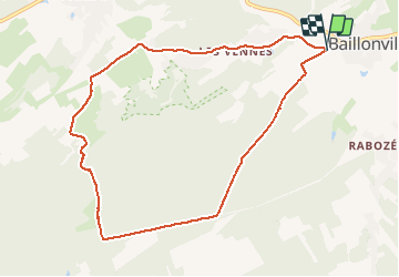
Baillonville-Heure (Somme-Leuze)

thomarche
Gebruiker

Lengte
8,7 km

Max. hoogte
284 m

Positief hoogteverschil
146 m
Km-Effort
10,6 km

Min. hoogte
183 m

Negatief hoogteverschil
145 m
Boucle
Ja
Datum van aanmaak :
2021-03-28 13:56:16.0
Laatste wijziging :
2021-03-28 16:03:02.116
2h07
Moeilijkheid : Onbekend

Gratisgps-wandelapplicatie
 SityTrail
IGN / Geografische instituten
SityTrail Plus
De wereld gaat voor u open
Over ons
Tocht Stappen van 8,7 km beschikbaar op Wallonië, Namen, Somme-Leuze. Deze tocht wordt voorgesteld door thomarche.
Beschrijving
Tout balises jaunes. Macadam mais tout étroit et très peu fréquenté
Plaatsbepaling
Land:
Belgium
Regio :
Wallonië
Departement/Provincie :
Namen
Gemeente :
Somme-Leuze
Locatie:
Baillonville
Vertrek:(Dec)
Vertrek:(UTM)
666200 ; 5573379 (31U) N.
Opmerkingen