


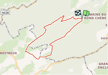
parc du mary . targnon . retour

stef789
Gebruiker GUIDE

Lengte
7,4 km

Max. hoogte
282 m

Positief hoogteverschil
128 m
Km-Effort
9,1 km

Min. hoogte
221 m

Negatief hoogteverschil
125 m
Boucle
Ja
Datum van aanmaak :
2021-04-01 08:36:03.371
Laatste wijziging :
2021-04-01 11:20:28.716
2h43
Moeilijkheid : Heel gemakkelijk

Gratisgps-wandelapplicatie
 SityTrail
IGN / Geografische instituten
SityTrail Plus
De wereld gaat voor u open
Over ons
Tocht Stappen van 7,4 km beschikbaar op Wallonië, Luik, Esneux. Deze tocht wordt voorgesteld door stef789.
Foto's


Plaatsbepaling
Land:
Belgium
Regio :
Wallonië
Departement/Provincie :
Luik
Gemeente :
Esneux
Locatie:
Esneux
Vertrek:(Dec)
Vertrek:(UTM)
680378 ; 5599425 (31U) N.
Opmerkingen