


remouchamps . deigne . playe . remouchamps

stef789
Gebruiker GUIDE
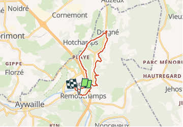

Lengte
10,2 km

Max. hoogte
239 m

Positief hoogteverschil
242 m
Km-Effort
13,4 km

Min. hoogte
128 m

Negatief hoogteverschil
242 m
Boucle
Ja
Datum van aanmaak :
2021-04-03 08:05:54.372
Laatste wijziging :
2021-04-03 11:46:31.598
3h39
Moeilijkheid : Heel gemakkelijk

Gratisgps-wandelapplicatie
 SityTrail
IGN / Geografische instituten
SityTrail Plus
De wereld gaat voor u open
Over ons
Tocht Stappen van 10,2 km beschikbaar op Wallonië, Luik, Aywaille. Deze tocht wordt voorgesteld door stef789.
Beschrijving
rando 46 jours après operation tendon quadriceps
Foto's


Plaatsbepaling
Land:
Belgium
Regio :
Wallonië
Departement/Provincie :
Luik
Gemeente :
Aywaille
Locatie:
Sougné-Remouchamps
Vertrek:(Dec)
Vertrek:(UTM)
692283 ; 5595499 (31U) N.
Opmerkingen