


Samrée

AnneCecile
Gebruiker
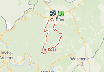

Lengte
9,7 km

Max. hoogte
570 m

Positief hoogteverschil
313 m
Km-Effort
13,9 km

Min. hoogte
348 m

Negatief hoogteverschil
313 m
Boucle
Ja
Datum van aanmaak :
2021-04-10 16:59:08.048
Laatste wijziging :
2021-04-10 17:39:04.422

Gratisgps-wandelapplicatie
 SityTrail
IGN / Geografische instituten
SityTrail Plus
De wereld gaat voor u open
Over ons
Tocht van 9,7 km beschikbaar op Wallonië, Luxemburg, La Roche-en-Ardenne. Deze tocht wordt voorgesteld door AnneCecile.
Plaatsbepaling
Land:
Belgium
Regio :
Wallonië
Departement/Provincie :
Luxemburg
Gemeente :
La Roche-en-Ardenne
Locatie:
Samrée
Vertrek:(Dec)
Vertrek:(UTM)
688320 ; 5565154 (31U) N.
Opmerkingen