


wasquehal RL

jeanluc59
Gebruiker
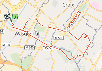

Lengte
12,5 km

Max. hoogte
52 m

Positief hoogteverschil
92 m
Km-Effort
13,7 km

Min. hoogte
17 m

Negatief hoogteverschil
93 m
Boucle
Ja
Datum van aanmaak :
2021-04-12 08:08:50.221
Laatste wijziging :
2021-04-12 10:04:54.369
3h06
Moeilijkheid : Gemakkelijk

Gratisgps-wandelapplicatie
 SityTrail
IGN / Geografische instituten
SityTrail Plus
De wereld gaat voor u open
Over ons
Tocht Te voet van 12,5 km beschikbaar op Hauts-de-France, Noorderdepartement, Wasquehal. Deze tocht wordt voorgesteld door jeanluc59.
Plaatsbepaling
Land:
France
Regio :
Hauts-de-France
Departement/Provincie :
Noorderdepartement
Gemeente :
Wasquehal
Locatie:
Unknown
Vertrek:(Dec)
Vertrek:(UTM)
508613 ; 5613488 (31U) N.
Opmerkingen