


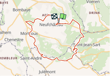
Neufchateau 17km?

wandelgidszuidlimburg
Gebruiker

Lengte
16,9 km

Max. hoogte
253 m

Positief hoogteverschil
292 m
Km-Effort
21 km

Min. hoogte
104 m

Negatief hoogteverschil
292 m
Boucle
Ja
Datum van aanmaak :
2014-12-10 00:00:00.0
Laatste wijziging :
2014-12-10 00:00:00.0
--
Moeilijkheid : Onbekend

Gratisgps-wandelapplicatie
 SityTrail
IGN / Geografische instituten
SityTrail Plus
De wereld gaat voor u open
Over ons
Tocht Stappen van 16,9 km beschikbaar op Wallonië, Luik, Dalhem. Deze tocht wordt voorgesteld door wandelgidszuidlimburg.
Beschrijving
More information on : http://www.wandelgidszuidlimburg.com


Plaatsbepaling
Land:
Belgium
Regio :
Wallonië
Departement/Provincie :
Luik
Gemeente :
Dalhem
Locatie:
Neufchâteau
Vertrek:(Dec)
Vertrek:(UTM)
696591 ; 5622435 (31U) N.
Opmerkingen
Très jolie balade ! Effectuée sous un beau soleil. Les paysages sont splendides
Belle balade campagnarde. ➡️📄 293.