


GR10 col d'Irau - col Bagargiak

winkelmuller
Gebruiker
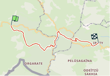

Lengte
12,6 km

Max. hoogte
1430 m

Positief hoogteverschil
854 m
Km-Effort
23 km

Min. hoogte
994 m

Negatief hoogteverschil
557 m
Boucle
Neen
Datum van aanmaak :
2021-04-27 13:39:30.141
Laatste wijziging :
2021-04-27 16:04:46.437
5h13
Moeilijkheid : Moeilijk

Gratisgps-wandelapplicatie
 SityTrail
IGN / Geografische instituten
SityTrail Plus
De wereld gaat voor u open
Over ons
Tocht Stappen van 12,6 km beschikbaar op Nieuw-Aquitanië, Pyrénées-Atlantiques, Lecumberry. Deze tocht wordt voorgesteld door winkelmuller.
Plaatsbepaling
Land:
France
Regio :
Nieuw-Aquitanië
Departement/Provincie :
Pyrénées-Atlantiques
Gemeente :
Lecumberry
Locatie:
Unknown
Vertrek:(Dec)
Vertrek:(UTM)
652681 ; 4768377 (30T) N.
Opmerkingen