


senlis

jojo02
Gebruiker
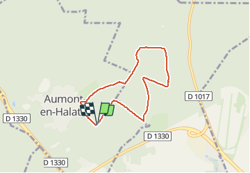

Lengte
5,8 km

Max. hoogte
127 m

Positief hoogteverschil
68 m
Km-Effort
6,7 km

Min. hoogte
89 m

Negatief hoogteverschil
68 m
Boucle
Ja
Datum van aanmaak :
2021-05-05 14:11:32.212
Laatste wijziging :
2021-05-05 14:49:41.135
37m
Moeilijkheid : Heel gemakkelijk

Gratisgps-wandelapplicatie
 SityTrail
IGN / Geografische instituten
SityTrail Plus
De wereld gaat voor u open
Over ons
Tocht Lopen van 5,8 km beschikbaar op Hauts-de-France, Oise, Aumont-en-Halatte. Deze tocht wordt voorgesteld door jojo02.
Plaatsbepaling
Land:
France
Regio :
Hauts-de-France
Departement/Provincie :
Oise
Gemeente :
Aumont-en-Halatte
Locatie:
Unknown
Vertrek:(Dec)
Vertrek:(UTM)
468125 ; 5452694 (31U) N.
Opmerkingen