


SityTrail - Remouchamps Hé des Gattes 10 Km

Efr
Gebruiker
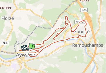

Lengte
13 km

Max. hoogte
305 m

Positief hoogteverschil
471 m
Km-Effort
19,3 km

Min. hoogte
119 m

Negatief hoogteverschil
473 m
Boucle
Ja
Datum van aanmaak :
2021-05-05 21:01:00.969
Laatste wijziging :
2024-12-07 20:13:24.49
4h23
Moeilijkheid : Gemakkelijk

Gratisgps-wandelapplicatie
 SityTrail
IGN / Geografische instituten
SityTrail Plus
De wereld gaat voor u open
Over ons
Tocht Te voet van 13 km beschikbaar op Wallonië, Luik, Aywaille. Deze tocht wordt voorgesteld door Efr.
Beschrijving
Depart: parking ,picine Aywaille
Plaatsbepaling
Land:
Belgium
Regio :
Wallonië
Departement/Provincie :
Luik
Gemeente :
Aywaille
Locatie:
Unknown
Vertrek:(Dec)
Vertrek:(UTM)
689977 ; 5595036 (31U) N.
Opmerkingen