


Wikiloc - shared-route (21)

AnneCecile
Gebruiker

Lengte
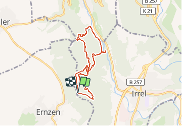
6,4 km

Max. hoogte
344 m

Positief hoogteverschil
210 m
Km-Effort
9,2 km

Min. hoogte
192 m

Negatief hoogteverschil
214 m
Boucle
Ja
Datum van aanmaak :
2021-05-08 12:28:00.218
Laatste wijziging :
2021-05-08 12:29:41.023

Gratisgps-wandelapplicatie
 SityTrail
IGN / Geografische instituten
SityTrail Plus
De wereld gaat voor u open
Over ons
Tocht van 6,4 km beschikbaar op Rijnland-Palts, Eifelkreis Bitburg-Prüm, Irrel. Deze tocht wordt voorgesteld door AnneCecile.
Plaatsbepaling
Land:
Germany
Regio :
Rijnland-Palts
Departement/Provincie :
Eifelkreis Bitburg-Prüm
Gemeente :
Irrel
Locatie:
Unknown
Vertrek:(Dec)
Vertrek:(UTM)
315628 ; 5524752 (32U) N.
Opmerkingen