


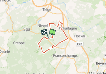
aérodrome, vecquée, Wayai, Nivezée et retour

bastinbe
Gebruiker

Lengte
19,7 km

Max. hoogte
577 m

Positief hoogteverschil
352 m
Km-Effort
24 km

Min. hoogte
352 m

Negatief hoogteverschil
354 m
Boucle
Ja
Datum van aanmaak :
2021-05-13 19:38:25.79
Laatste wijziging :
2021-05-26 16:50:08.306
4h30
Moeilijkheid : Moeilijk

Gratisgps-wandelapplicatie
 SityTrail
IGN / Geografische instituten
SityTrail Plus
De wereld gaat voor u open
Over ons
Tocht Te voet van 19,7 km beschikbaar op Wallonië, Luik, Spa. Deze tocht wordt voorgesteld door bastinbe.
Plaatsbepaling
Land:
Belgium
Regio :
Wallonië
Departement/Provincie :
Luik
Gemeente :
Spa
Locatie:
Unknown
Vertrek:(Dec)
Vertrek:(UTM)
706681 ; 5595821 (31U) N.
Opmerkingen