


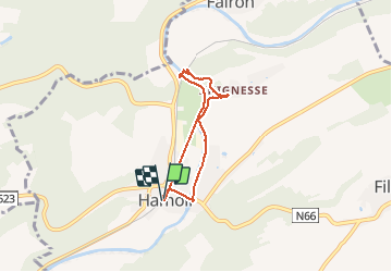
Circuit Tabreux

Michel GUISSE
Gebruiker

Lengte
4,8 km

Max. hoogte
144 m

Positief hoogteverschil
44 m
Km-Effort
5,4 km

Min. hoogte
108 m

Negatief hoogteverschil
45 m
Boucle
Ja
Datum van aanmaak :
2021-05-15 12:41:36.0
Laatste wijziging :
2021-05-15 15:00:22.456
1h35
Moeilijkheid : Gemakkelijk

Gratisgps-wandelapplicatie
 SityTrail
IGN / Geografische instituten
SityTrail Plus
De wereld gaat voor u open
Over ons
Tocht Stappen van 4,8 km beschikbaar op Wallonië, Luik, Hamoir. Deze tocht wordt voorgesteld door Michel GUISSE.
Beschrijving
Rive Dr - Crahoûte - Tabreux - Ravel
Plaatsbepaling
Land:
Belgium
Regio :
Wallonië
Departement/Provincie :
Luik
Gemeente :
Hamoir
Locatie:
Hamoir
Vertrek:(Dec)
Vertrek:(UTM)
679862 ; 5589017 (31U) N.
Opmerkingen