


Face (61)

Eve - Line
Gebruiker

Lengte
24 km

Max. hoogte
292 m

Positief hoogteverschil
507 m
Km-Effort
31 km

Min. hoogte
151 m

Negatief hoogteverschil
508 m
Boucle
Ja
Datum van aanmaak :
2021-05-18 07:36:11.959
Laatste wijziging :
2021-05-18 13:32:53.681
5h27
Moeilijkheid : Medium

Gratisgps-wandelapplicatie
 SityTrail
IGN / Geografische instituten
SityTrail Plus
De wereld gaat voor u open
Over ons
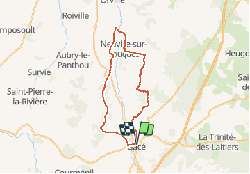
Tocht Stappen van 24 km beschikbaar op Normandië, Orne, Gacé. Deze tocht wordt voorgesteld door Eve - Line.
Plaatsbepaling
Land:
France
Regio :
Normandië
Departement/Provincie :
Orne
Gemeente :
Gacé
Locatie:
Unknown
Vertrek:(Dec)
Vertrek:(UTM)
301419 ; 5408291 (31U) N.
Opmerkingen