


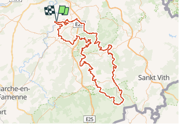
GR573_Pacours-principal_2021-02-14

ramagufa
Gebruiker

Lengte
186 km

Max. hoogte
579 m

Positief hoogteverschil
5267 m
Km-Effort
256 km

Min. hoogte
97 m

Negatief hoogteverschil
5269 m
Boucle
Ja
Datum van aanmaak :
2021-05-21 17:27:28.874
Laatste wijziging :
2021-05-21 17:34:42.965
58h16
Moeilijkheid : Zeer moeilijk

Gratisgps-wandelapplicatie
 SityTrail
IGN / Geografische instituten
SityTrail Plus
De wereld gaat voor u open
Over ons
Tocht Stappen van 186 km beschikbaar op Wallonië, Luik, Comblain-au-Pont. Deze tocht wordt voorgesteld door ramagufa.
Beschrijving
Itinéraire : Pont-de-Sçay - Remouchamps - Trois-Ponts - Salmchâteau - Gouvy - Lierneux - Chevron - Lorcé - Xhoris - Pont-de-Sçay
Plaatsbepaling
Land:
Belgium
Regio :
Wallonië
Departement/Provincie :
Luik
Gemeente :
Comblain-au-Pont
Locatie:
Unknown
Vertrek:(Dec)
Vertrek:(UTM)
683731 ; 5595171 (31U) N.
Opmerkingen