


Senlis 12km

Djaie60
Gebruiker
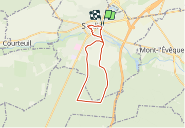

Lengte
11,2 km

Max. hoogte
81 m

Positief hoogteverschil
96 m
Km-Effort
12,5 km

Min. hoogte
50 m

Negatief hoogteverschil
96 m
Boucle
Ja
Datum van aanmaak :
2021-05-23 16:57:36.0
Laatste wijziging :
2021-06-23 09:55:00.226
2h50
Moeilijkheid : Gemakkelijk

Gratisgps-wandelapplicatie
 SityTrail
IGN / Geografische instituten
SityTrail Plus
De wereld gaat voor u open
Over ons
Tocht Te voet van 11,2 km beschikbaar op Hauts-de-France, Oise, Senlis. Deze tocht wordt voorgesteld door Djaie60.
Plaatsbepaling
Land:
France
Regio :
Hauts-de-France
Departement/Provincie :
Oise
Gemeente :
Senlis
Locatie:
Unknown
Vertrek:(Dec)
Vertrek:(UTM)
470305 ; 5450473 (31U) N.
Opmerkingen